Ta mapa jest interaktywna! Użyj kontrolek celem przybliżenia i oddalenia.
|
Data: WGS84 [ Pomocy ]
Dokładność: W przybliżeniu
Historia GPS (3)
|
Szerokość geograficzna: 43° 3.179' N
Długość geograficzna: 16° 2.366' E
|
Dostęp
|
Jak? Łodzią
Odległość Długi czas na łodzi
Łatwo znaleźć? Łatwe do znalezienia
|
|
Charakterystyka miejsca nurkowego
Nazwa dodatkowa Mali Barjak, ex ACOREANO, ex BIRKELUND, ex CAIALA, ex MAGNA, ex UDSIRE, ex ARCHIDUC RODOLPHE
Przeciętna głebokość 8 m / 26.2 ft
maksymalna głębokość 34 m / 111.5 ft
Prąd Średnio( 1-2 knots)
Widoczność Dobry ( 10 - 30 m)
Jakość
Jakość miejsca nurkowania Świetny
Doświadczenie Dla każdego nurka
Interesujący biologicznie Interesujący
Więcej informacji
Ilość nurków w tygodniu
Ilość nurków w week-end
Nurkowanie typu
- Wrak
Aktywności w miejscu
- Nocne nurkowanie
- Fotografia
Niebezpieczeństwa
Dodatkowe informacje
English (Przetłumacz ten tekst w Polski): TETI was built in 1883 in Hoboken-USA by John Cockerill Shipyard. She was 72m long, 8m wide with 963 BRT. On the 23rd May 1930 she hit the island of Mali Barjak with a cargo of paving stones due to a navigation mistake. The entire bow is smashed by the waves but the stern is still intact and offers great photo opportunities.
English (Przetłumacz ten tekst w Polski): TETI was built in 1883 in Hoboken-USA by John Cockerill Shipyard. She was 72m long, 8m wide with 963 BRT. On the 23rd May 1930 she hit the island of Mali Barjak with a cargo of paving stones due to a navigation mistake. The entire bow is smashed by the waves but the stern is still intact and offers great photo opportunities.
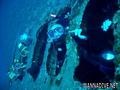
TETI was built in 1883 in Hoboken-USA by John Cockerill Shipyard. She was 72m long, 8m wide with 963 BRT. On the 23rd May 1930 she hit the island of Mali Barjak with a cargo of paving stones due to a navigation mistake. The entire bow is smashed by the waves but the stern is still intact and offers great photo opportunities.
English (Przetłumacz ten tekst w Polski): TETI was built in 1883 in Hoboken-USA by John Cockerill Shipyard. She was 72m long, 8m wide with 963 BRT. On the 23rd May 1930 she hit the island of Mali Barjak with a cargo of paving stones due to a navigation mistake. The entire bow is smashed by the waves but the stern is still intact and offers great photo opportunities.
English (Przetłumacz ten tekst w Polski): TETI was built in 1883 in Hoboken-USA by John Cockerill Shipyard. She was 72m long, 8m wide with 963 BRT. On the 23rd May 1930 she hit the island of Mali Barjak with a cargo of paving stones due to a navigation mistake. The entire bow is smashed by the waves but the stern is still intact and offers great photo opportunities.
English (Przetłumacz ten tekst w Polski): TETI was built in 1883 in Hoboken-USA by John Cockerill Shipyard. She was 72m long, 8m wide with 963 BRT. On the 23rd May 1930 she hit the island of Mali Barjak with a cargo of paving stones due to a navigation mistake. The entire bow is smashed by the waves but the stern is still intact and offers great photo opportunities.
English (Przetłumacz ten tekst w Polski): TETI was built in 1883 in Hoboken-USA by John Cockerill Shipyard. She was 72m long, 8m wide with 963 BRT. On the 23rd May 1930 she hit the island of Mali Barjak with a cargo of paving stones due to a navigation mistake. The entire bow is smashed by the waves but the stern is still intact and offers great photo opportunities.
English (Przetłumacz ten tekst w Polski): TETI was built in 1883 in Hoboken-USA by John Cockerill Shipyard. She was 72m long, 8m wide with 963 BRT. On the 23rd May 1930 she hit the island of Mali Barjak with a cargo of paving stones due to a navigation mistake. The entire bow is smashed by the waves but the stern is still intact and offers great photo opportunities.
English (Przetłumacz ten tekst w Polski): TETI was built in 1883 in Hoboken-USA by John Cockerill Shipyard. She was 72m long, 8m wide with 963 BRT. On the 23rd May 1930 she hit the island of Mali Barjak with a cargo of paving stones due to a navigation mistake. The entire bow is smashed by the waves but the stern is still intact and offers great photo opportunities.
 Komentarze
Pokaż wszystko (0)...
To będzie pierwszy komentarz o tym kraju
Błąd, powiadom nas o błędzie
możesz skorygować te błędy lub dodać informacje. Jeśli masz problemy odwiedź ta stronę, Wyślij nam odpowiedź zwrotną.
Wannadive.net 24/24
Wannadive.net na Twoim urządzeniu mobilnym

Biuletyn Wiadomości na email
 Wreck Teti