Utracono hasło? Nowy użytkownik? Zarejestruj się
Clownfish, Philippines. Photo by Stephane Rochon.
Baw się i pomagaj!
| Znajdź najlepsze miejsce nurkowe |
|
|
 Federal State of Micronesia
Australia i Pacyfik
Lokalizacja: Oceania, island group in the North Pacific Ocean, about three-quarters of the way from Hawaii to Indonesia.
Koordynaty geograficzne: 6° 33' N, 158° 9' E
Linia brzegowa: 6,112 km km
Klimat: tropical; heavy year-round rainfall, especially in the eastern islands; located on southern edge of the typhoon belt with occasionally severe damage
Teren: islands vary geologically from high mountainous islands to low, coral atolls; volcanic outcroppings on Pohnpei, Kosrae, and Chuuk
Najwyższy punkt: highest point: Dolohmwar (Totolom) 791 m
Naturalne zagrożenia: typhoons (June to December)
Waluta: US dollar (USD)
Populacja: 108,105 (July 2005 est.)
Języki: English (official and common language), Trukese, Pohnpeian, Yapese, Kosrean, Ulithian, Woleaian, Nukuoro, Kapingamarangi
Stolica: Palikir
Podział: 4 states; Chuuk (Truk), Kosrae (Kosaie), Pohnpei (Ponape), Yap
Więcej szczegółów
| Jan | Feb | Mar | Apr | May | Jun | Jul | Aug | Sep | Oct | Nov | Dec | |
|---|---|---|---|---|---|---|---|---|---|---|---|---|
| Climate | ||||||||||||
| Air temp. | ||||||||||||
| Water temp. | ||||||||||||
| Equipment | ||||||||||||
| Best season | ||||||||||||
Dodatkowa mapa
Chcesz dodać jakąś informację o Federal State of Micronesia? Znamy....
Ta mapa jest interaktywna! Użyj kontrolek celem przybliżenia i oddalenia.
- dive logs (5)
- podróże (0)
- Zdjecia (80)
- Filmy (1)
- Podziel się
- Ulubione
-
Twoje ulubione i przyszłe miejsca nurkowe
Twój ulubiony obszar nie jest wyswietlany? Dodaj obszar
Miejsca
| Miejsca (5) | Miejsca nurkowania | Pod-obszary |
|---|---|---|
| Guam | 7 | 0 |
| Kosrae | 1 | 0 |
| Pohnpei | 10 | 0 |
| Truk Lagoon | 16 | 0 |
| Yap | 20 | 0 |
Miejsca nurkowania
| Miejsca nurkowania (2) | Jakość | Średnia głębokość | Maksymalna głębokość | Doświadczenie | Typ nurkowania | ||
|---|---|---|---|---|---|---|---|
| Lelu Aeroplane | - / - | 20 m | 35 m | CMAS * / OW | 

|
||
| Lelu Wrecks | - / - | 18 m | 30 m | CMAS * / OW |
|
 Zdjecia
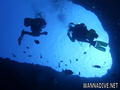
Blue hole |
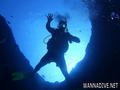
Blue hole |
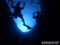
Blue hole |
Blue hole |
Dive logs
|
Komentarze
Błąd, powiadom nas o błędzie
Jeśli chcesz dodać nowe informacje lub znalazłeś błędy w opisie tego kraju, Wyślij nam odpowiedź zwrotną.