Lokalizacja: Southern Asia, bordering the Arabian Sea and the Bay of Bengal, between Burma and Pakistan
Koordynaty geograficzne: 20° 0' N, 77° 0' E
Linia brzegowa: 7,000 km km
Klimat: varies from tropical monsoon in south to temperate in north
Teren: upland plain (Deccan Plateau) in south, flat to rolling plain along the Ganges, deserts in west, Himalayas in north
Najwyższy punkt:
Naturalne zagrożenia: droughts; flash floods, as well as widespread and destructive flooding from monsoonal rains; severe thunderstorms; earthquakes
Waluta: Indian rupee (INR)
Populacja:
Języki: English enjoys associate status but is the most important language for national, political, and commercial communication; Hindi is the national language and primary tongue of 30% of the people
Stolica:
Podział:
Więcej szczegółów
| |
Sezony |
| Jan |
Feb |
Mar |
Apr |
May |
Jun |
Jul |
Aug |
Sep |
Oct |
Nov |
Dec |
| Climate |
|
|
|
|
|
|
|
|
|
|
|
|
| Air temp. |
|
|
|
|
|
|
|
|
|
|
|
|
| Water temp. |
|
|
|
|
|
|
|
|
|
|
|
|
| Equipment |
|
|
|
|
|
|
|
|
|
|
|
|
| Best season |
|
|
|
|
|
|
|
|
|
|
|
|
Chcesz poprawić lub uzupełnić te dane? Edytuj tę stronę
Chcesz dodać jakąś informację o India? Znamy....
Ta mapa jest interaktywna! Użyj kontrolek celem przybliżenia i oddalenia.
Twój ulubiony obszar nie jest wyswietlany? Dodaj obszar
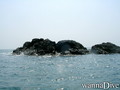
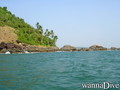
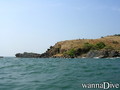
Miejsca
 Komentarze
Pokaż wszystko (0)...
To będzie pierwszy komentarz o tym kraju
Błąd, powiadom nas o błędzie
Jeśli chcesz dodać nowe informacje lub znalazłeś błędy w opisie tego kraju, Wyślij nam odpowiedź zwrotną.
Wannadive.net 24/24
Wannadive.net na Twoim urządzeniu mobilnym

Biuletyn Wiadomości na email
 India
India