Utracono hasło? Nowy użytkownik? Zarejestruj się
Lizard fish, Philippines. Photo by Stephane Rochon.
Baw się i pomagaj!
| Znajdź najlepsze miejsce nurkowe |
|
|
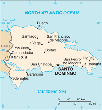
 Dominican Republic
Ameryka Środkowa
Famous dive area near Santo Domingo is "La Caleta", an underwater national park with wrecks such as the "The Hickory" wreck, "El Limon" wreck...
Lokalizacja: Caribbean, eastern two-thirds of the island of Hispaniola, between the Caribbean Sea and the North Atlantic Ocean, east of Haiti
Koordynaty geograficzne: 19° 0' N, 70° 40' W
Linia brzegowa: 1,288 km km
Klimat: tropical maritime; little seasonal temperature variation; seasonal variation in rainfall
Teren: rugged highlands and mountains with fertile valleys interspersed
Najwyższy punkt: lowest point: Lago Enriquillo -46 m
highest point: Pico Duarte 3,175 m
Naturalne zagrożenia: lies in the middle of the hurricane belt and subject to severe storms from June to October; occasional flooding; periodic droughts
Waluta: Dominican peso (DOP)
Populacja: 9,183,984 (July 2006 est.)
Języki: Spanish
Stolica: Santo Domingo
Podział: 31 provinces (provincias, singular - provincia) and 1 district* (distrito); Azua, Baoruco, Barahona, Dajabon, Distrito Nacional*, Duarte, El Seibo, Elias Pina, Espaillat, Hato Mayor, Independencia, La Altagracia, La Romana, La Vega, Maria Trinidad Sanchez, Monsenor Nouel, Monte Cristi, Monte Plata, Pedernales, Peravia, Puerto Plata, Salcedo, Samana, San Cristobal, San Jose de Ocoa, San Juan, San Pedro de Macoris, Sanchez Ramirez, Santiago, Santiago Rodriguez, Santo Domingo, Valverde
Więcej szczegółów
| Jan | Feb | Mar | Apr | May | Jun | Jul | Aug | Sep | Oct | Nov | Dec | |
|---|---|---|---|---|---|---|---|---|---|---|---|---|
| Climate | ||||||||||||
| Air temp. | ||||||||||||
| Water temp. | ||||||||||||
| Equipment | Je ne sais pas | Je ne sais pas | Je ne sais pas | Je ne sais pas | Je ne sais pas | Je ne sais pas | Je ne sais pas | Je ne sais pas | Je ne sais pas | Je ne sais pas | Je ne sais pas | Je ne sais pas |
| Best season | ||||||||||||
Dodatkowa mapa
Chcesz dodać jakąś informację o Dominican Republic? Znamy....
Ta mapa jest interaktywna! Użyj kontrolek celem przybliżenia i oddalenia.
- dive logs (82)
- podróże (4)
- Zdjecia (131)
- Filmy (1)
- Podziel się
- Ulubione
-
Twoje ulubione i przyszłe miejsca nurkowe
Twój ulubiony obszar nie jest wyswietlany? Dodaj obszar
Miejsca
| Miejsca (5) | Miejsca nurkowania | Pod-obszary |
|---|---|---|
| Boca Chica | 2 | 0 |
| Juan Dolio | 6 | 0 |
| La Romana and Saona Island | 12 | 0 |
| Puerto Plata area | 17 | 0 |
| Punta Cana | 13 | 0 |
Miejsca nurkowania
| Miejsca nurkowania (5) | Jakość | Średnia głębokość | Maksymalna głębokość | Doświadczenie | Typ nurkowania | ||
|---|---|---|---|---|---|---|---|
| Aquario Reef | 2 / - | 15 m | 16 m | Dla każdego nurka | 
|
||
| Coral Garden (Luperon) | - / - | 18 m | 25 m | CMAS ** / AOW | 

|
||
| Cuevas de Du-du | 9 / 1 | 10 m | 13 m | CMAS ** / AOW | 
|
||
| El Derrumbao | 4 / - | 30 m | 37 m | CMAS ** / AOW | 
|
||
| Patricia Wreck | 3 / - | 15 m | 18 m | CMAS * / OW |
|
 Zdjecia
Aquario Reef |

Parque Nacional La Caleta |

Parque Nacional La Caleta |

Parque Nacional La Caleta |

Dive logs
|
Wycieczki nurkowe
|
Komentarze
Błąd, powiadom nas o błędzie
Jeśli chcesz dodać nowe informacje lub znalazłeś błędy w opisie tego kraju, Wyślij nam odpowiedź zwrotną.