Ta mapa jest interaktywna! Użyj kontrolek celem przybliżenia i oddalenia.
|
Data: WGS84 [ Pomocy ]
Dokładność: W przybliżeniu
Historia GPS (4)
|
Szerokość geograficzna: 26° 28.972' N
Długość geograficzna: 78° 40.221' W
|
Dostęp
|
English (Przetłumacz ten tekst w Polski): SW of Grand Bahama island: just W of Silver Point and E of Xanadu Beach, about 1.5 miles off the coast. Two permanent buoys mark the ship’s position (one at the bow and one at the stern).
English (Przetłumacz ten tekst w Polski): SW of Grand Bahama island: just W of Silver Point and E of Xanadu Beach, about 1.5 miles off the coast. Two permanent buoys mark the ship’s position (one at the bow and one at the stern).
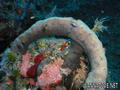
SW of Grand Bahama island: just W of Silver Point and E of Xanadu Beach, about 1.5 miles off the coast. Two permanent buoys mark the ship’s position (one at the bow and one at the stern).
English (Przetłumacz ten tekst w Polski): SW of Grand Bahama island: just W of Silver Point and E of Xanadu Beach, about 1.5 miles off the coast. Two permanent buoys mark the ship’s position (one at the bow and one at the stern).
English (Przetłumacz ten tekst w Polski): SW of Grand Bahama island: just W of Silver Point and E of Xanadu Beach, about 1.5 miles off the coast. Two permanent buoys mark the ship’s position (one at the bow and one at the stern).
English (Przetłumacz ten tekst w Polski): SW of Grand Bahama island: just W of Silver Point and E of Xanadu Beach, about 1.5 miles off the coast. Two permanent buoys mark the ship’s position (one at the bow and one at the stern).
English (Przetłumacz ten tekst w Polski): SW of Grand Bahama island: just W of Silver Point and E of Xanadu Beach, about 1.5 miles off the coast. Two permanent buoys mark the ship’s position (one at the bow and one at the stern).
English (Przetłumacz ten tekst w Polski): SW of Grand Bahama island: just W of Silver Point and E of Xanadu Beach, about 1.5 miles off the coast. Two permanent buoys mark the ship’s position (one at the bow and one at the stern).
English (Przetłumacz ten tekst w Polski): SW of Grand Bahama island: just W of Silver Point and E of Xanadu Beach, about 1.5 miles off the coast. Two permanent buoys mark the ship’s position (one at the bow and one at the stern).
Jak? Łodzią
Odległość Dobry czas na łodzi (< 30min)
Łatwo znaleźć? Trudne do znalezienia
|
|
Charakterystyka miejsca nurkowego
Nazwa dodatkowa M/S Logna
Przeciętna głebokość 25 m / 82 ft
maksymalna głębokość 31 m / 101.7 ft
Prąd Powoli( < 1 knot)
Widoczność Dobry ( 10 - 30 m)
Jakość
Jakość miejsca nurkowania Dobry
Doświadczenie CMAS ** / AOW
Interesujący biologicznie Wybitny
Więcej informacji
Ilość nurków w tygodniu
Ilość nurków w week-end
Nurkowanie typu
- Wrak
Aktywności w miejscu
- Fotografia
Niebezpieczeństwa
Dodatkowe informacje
English (Przetłumacz ten tekst w Polski): This 230 feet long vessel was built in Norway in 1954. It was intentionally sunk october 16, 1982. She now lays on her port side on a flat sandy floor, not far from few isolated coral banks.
English (Przetłumacz ten tekst w Polski): This 230 feet long vessel was built in Norway in 1954. It was intentionally sunk october 16, 1982. She now lays on her port side on a flat sandy floor, not far from few isolated coral banks.
This 230 feet long vessel was built in Norway in 1954. It was intentionally sunk october 16, 1982. She now lays on her port side on a flat sandy floor, not far from few isolated coral banks.
English (Przetłumacz ten tekst w Polski): This 230 feet long vessel was built in Norway in 1954. It was intentionally sunk october 16, 1982. She now lays on her port side on a flat sandy floor, not far from few isolated coral banks.
English (Przetłumacz ten tekst w Polski): This 230 feet long vessel was built in Norway in 1954. It was intentionally sunk october 16, 1982. She now lays on her port side on a flat sandy floor, not far from few isolated coral banks.
English (Przetłumacz ten tekst w Polski): This 230 feet long vessel was built in Norway in 1954. It was intentionally sunk october 16, 1982. She now lays on her port side on a flat sandy floor, not far from few isolated coral banks.
English (Przetłumacz ten tekst w Polski): This 230 feet long vessel was built in Norway in 1954. It was intentionally sunk october 16, 1982. She now lays on her port side on a flat sandy floor, not far from few isolated coral banks.
English (Przetłumacz ten tekst w Polski): This 230 feet long vessel was built in Norway in 1954. It was intentionally sunk october 16, 1982. She now lays on her port side on a flat sandy floor, not far from few isolated coral banks.
English (Przetłumacz ten tekst w Polski): This 230 feet long vessel was built in Norway in 1954. It was intentionally sunk october 16, 1982. She now lays on her port side on a flat sandy floor, not far from few isolated coral banks.
 Komentarze
Pokaż wszystko (2)...
Błąd, powiadom nas o błędzie
możesz skorygować te błędy lub dodać informacje. Jeśli masz problemy odwiedź ta stronę, Wyślij nam odpowiedź zwrotną.
Wannadive.net 24/24
Wannadive.net na Twoim urządzeniu mobilnym

Biuletyn Wiadomości na email
 Theo's Wreck

Obok Theo Galanopoulos , 14-05-2010
Theo (From Theo's Wreck) - I Like the plaque... Thanks