Ta mapa jest interaktywna! Użyj kontrolek celem przybliżenia i oddalenia.
|
Data: WGS84 [ Pomocy ]
Dokładność: W przybliżeniu
Historia GPS (3)
|
Szerokość geograficzna: 24° 38.897' N
Długość geograficzna: 51° 25.303' E
|
Dostęp
|
English (Przetłumacz ten tekst w Polski): Head for Othmans Reef, then at the final dune, turn right along the beach. Cross the sabkha till you get to the first dune at the sea edge. Not accessible at some states of the tide.
English (Przetłumacz ten tekst w Polski): Head for Othmans Reef, then at the final dune, turn right along the beach. Cross the sabkha till you get to the first dune at the sea edge. Not accessible at some states of the tide.
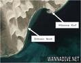
Head for Othmans Reef, then at the final dune, turn right along the beach. Cross the sabkha till you get to the first dune at the sea edge. Not accessible at some states of the tide.
English (Przetłumacz ten tekst w Polski): Head for Othmans Reef, then at the final dune, turn right along the beach. Cross the sabkha till you get to the first dune at the sea edge. Not accessible at some states of the tide.
English (Przetłumacz ten tekst w Polski): Head for Othmans Reef, then at the final dune, turn right along the beach. Cross the sabkha till you get to the first dune at the sea edge. Not accessible at some states of the tide.
English (Przetłumacz ten tekst w Polski): Head for Othmans Reef, then at the final dune, turn right along the beach. Cross the sabkha till you get to the first dune at the sea edge. Not accessible at some states of the tide.
English (Przetłumacz ten tekst w Polski): Head for Othmans Reef, then at the final dune, turn right along the beach. Cross the sabkha till you get to the first dune at the sea edge. Not accessible at some states of the tide.
English (Przetłumacz ten tekst w Polski): Head for Othmans Reef, then at the final dune, turn right along the beach. Cross the sabkha till you get to the first dune at the sea edge. Not accessible at some states of the tide.
English (Przetłumacz ten tekst w Polski): Head for Othmans Reef, then at the final dune, turn right along the beach. Cross the sabkha till you get to the first dune at the sea edge. Not accessible at some states of the tide.
Jak? Z brzegu
Odległość Krótki spacer na brzegu (< 5min)
Łatwo znaleźć? Trudne do znalezienia
|
|
Charakterystyka miejsca nurkowego
Nazwa dodatkowa Olivier Bank reef
Przeciętna głebokość 7 m / 23 ft
maksymalna głębokość 9 m / 29.5 ft
Prąd Powoli( < 1 knot)
Widoczność Średni( 5 - 10 m)
Jakość
Jakość miejsca nurkowania Normalny
Doświadczenie Dla każdego nurka
Interesujący biologicznie Interesujący
Więcej informacji
Ilość nurków w tygodniu
Ilość nurków w week-end
Nurkowanie typu
- Rafa
Aktywności w miejscu
- Biologia morska
Niebezpieczeństwa
Dodatkowe informacje
English (Przetłumacz ten tekst w Polski): 3 natural coral reefs. Named for Olivier, the club member who found the reef. Zeitoune is Arabic for olive.
Often rays on sandy crossing. The southernmost reef often has large hamour Fish at the bottom of the reef wall.
As you swim the gap, the depth will decrease as you approach the reef. If it starts getting quite deep, it means you have passed it. Turn back to shallow area, then turn either North or South
3 natural coral reefs. Named for Olivier, the club member who found the reef. Zeitoune is Arabic for olive.
Often rays on sandy crossing. The southernmost reef often has large hamour Fish at the bottom of the reef wall.
As you swim the gap, the depth will decrease as you approach the reef. If it starts getting quite deep, it means you have passed it. Turn back to shallow area, then turn either North or South
English (Przetłumacz ten tekst w Polski): 3 natural coral reefs. Named for Olivier, the club member who found the reef. Zeitoune is Arabic for olive.
Often rays on sandy crossing. The southernmost reef often has large hamour Fish at the bottom of the reef wall.
As you swim the gap, the depth will decrease as you approach the reef. If it starts getting quite deep, it means you have passed it. Turn back to shallow area, then turn either North or South
 Komentarze
Pokaż wszystko (0)...
To będzie pierwszy komentarz o tym kraju
Błąd, powiadom nas o błędzie
możesz skorygować te błędy lub dodać informacje. Jeśli masz problemy odwiedź ta stronę, Wyślij nam odpowiedź zwrotną.
Wannadive.net 24/24
Wannadive.net na Twoim urządzeniu mobilnym

Biuletyn Wiadomości na email
 Zeitoune Bank