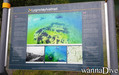
Ta mapa jest interaktywna! Użyj kontrolek celem przybliżenia i oddalenia.
|
Data: WGS84 [ Pomocy ]
Dokładność: W przybliżeniu
Historia GPS (1)
|
Szerokość geograficzna: 62° 10.479' N
Długość geograficzna: 6° 43.677' E
|
Dostęp
|
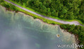
English (Przetłumacz ten tekst w Polski): Access from route 655 from øye in too the mountain
English (Przetłumacz ten tekst w Polski): Access from route 655 from øye in too the mountain
Access from route 655 from øye in too the mountain
English (Przetłumacz ten tekst w Polski): Access from route 655 from øye in too the mountain
English (Przetłumacz ten tekst w Polski): Access from route 655 from øye in too the mountain
English (Przetłumacz ten tekst w Polski): Access from route 655 from øye in too the mountain
English (Przetłumacz ten tekst w Polski): Access from route 655 from øye in too the mountain
English (Przetłumacz ten tekst w Polski): Access from route 655 from øye in too the mountain
English (Przetłumacz ten tekst w Polski): Access from route 655 from øye in too the mountain
Jak? Z brzegu
Odległość Natychmiastowy dostęp
Łatwo znaleźć? Łatwe do znalezienia
|
|
Charakterystyka miejsca nurkowego
Nazwa dodatkowa Civilizatione lost
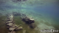
Przeciętna głebokość 10 m / 32.8 ft
maksymalna głębokość 18 m / 59.1 ft
Prąd Brak
Widoczność Dobry ( 10 - 30 m)
Jakość
Jakość miejsca nurkowania Świetny
Doświadczenie CMAS * / OW
Interesujący biologicznie Nic
Więcej informacji
Ilość nurków w tygodniu
Ilość nurków w week-end
Nurkowanie typu
- Woda słodka
Aktywności w miejscu
- Nocne nurkowanie
- Snurkowanie / nurkowanie swobodne
- Fotografia
- Nurkowania niepełnosprawnych
Niebezpieczeństwa
Dodatkowe informacje
English (Przetłumacz ten tekst w Polski): A small village that was flooded after a rock slide that blocked the river that flows down the valley and formed an artificial lake and flooded a farm that still stands as one can see today
The lake is at an altitude of ca 200 meter's above sea level
English (Przetłumacz ten tekst w Polski): A small village that was flooded after a rock slide that blocked the river that flows down the valley and formed an artificial lake and flooded a farm that still stands as one can see today
The lake is at an altitude of ca 200 meter's above sea level
A small village that was flooded after a rock slide that blocked the river that flows down the valley and formed an artificial lake and flooded a farm that still stands as one can see today
The lake is at an altitude of ca 200 meter's above sea level
English (Przetłumacz ten tekst w Polski): A small village that was flooded after a rock slide that blocked the river that flows down the valley and formed an artificial lake and flooded a farm that still stands as one can see today
The lake is at an altitude of ca 200 meter's above sea level
English (Przetłumacz ten tekst w Polski): A small village that was flooded after a rock slide that blocked the river that flows down the valley and formed an artificial lake and flooded a farm that still stands as one can see today
The lake is at an altitude of ca 200 meter's above sea level
English (Przetłumacz ten tekst w Polski): A small village that was flooded after a rock slide that blocked the river that flows down the valley and formed an artificial lake and flooded a farm that still stands as one can see today
The lake is at an altitude of ca 200 meter's above sea level
English (Przetłumacz ten tekst w Polski): A small village that was flooded after a rock slide that blocked the river that flows down the valley and formed an artificial lake and flooded a farm that still stands as one can see today
The lake is at an altitude of ca 200 meter's above sea level
English (Przetłumacz ten tekst w Polski): A small village that was flooded after a rock slide that blocked the river that flows down the valley and formed an artificial lake and flooded a farm that still stands as one can see today
The lake is at an altitude of ca 200 meter's above sea level
English (Przetłumacz ten tekst w Polski): A small village that was flooded after a rock slide that blocked the river that flows down the valley and formed an artificial lake and flooded a farm that still stands as one can see today
The lake is at an altitude of ca 200 meter's above sea level
 Komentarze
Pokaż wszystko (0)...
To będzie pierwszy komentarz o tym kraju
Błąd, powiadom nas o błędzie
możesz skorygować te błędy lub dodać informacje. Jeśli masz problemy odwiedź ta stronę, Wyślij nam odpowiedź zwrotną.
Wannadive.net 24/24
Wannadive.net na Twoim urządzeniu mobilnym

Biuletyn Wiadomości na email
 Lyngstølsvatnet