Utracono hasło? Nowy użytkownik? Zarejestruj się
Clownfish, Philippines. Photo by Stephane Rochon.
Baw się i pomagaj!
| Znajdź najlepsze miejsce nurkowe |
|
|
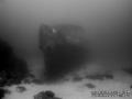
 Imperial Eagle MV
Malta, Malta island
Ta mapa jest interaktywna! Użyj kontrolek celem przybliżenia i oddalenia.
|
Data: WGS84 [ Pomocy ] |
Szerokość geograficzna: 35° 57.096' N |
Ocena użytkownika (1)
- Ulubione
-
Twoje ulubione i przyszłe miejsca nurkowe
Dostęp
|
Jak? Łodzią Odległość Dobry czas na łodzi (< 30min) Łatwo znaleźć? Łatwe do znalezienia |
Charakterystyka miejsca nurkowego
Nazwa dodatkowa Imperial Eagle ferry
Przeciętna głebokość 35 m / 114.8 ft
maksymalna głębokość 46 m / 150.9 ft
Prąd Powoli( < 1 knot)
Widoczność Dobry ( 10 - 30 m)
Jakość
Jakość miejsca nurkowania Świetny
Doświadczenie CMAS ** / AOW
Interesujący biologicznie Interesujący
Więcej informacji
Ilość nurków w tygodniu
Ilość nurków w week-end
Nurkowanie typu
- Wrak
Aktywności w miejscu
- Trening nurkowy
- Fotografia
Niebezpieczeństwa
- Głebokość
Dodatkowe informacje
English (Przetłumacz ten tekst w Polski): The Imperial Eagle was one of the ferryboats connecting Malta and Gozo.
The hull, in navigation trim, lays on a sandy bottom at a depth of -42m, 300m North-East of Qwara Point.
Autor: Vladimir Dunaev Współpracownicy (1) Oni nurkowali w tym miejscu! (6)
 Zdjecia

Imperial Eagle MV |

Imperial Eagle MV |

Imperial Eagle MV |
Imperial Eagle MV |
Komentarze
To będzie pierwszy komentarz o tym kraju
Błąd, powiadom nas o błędzie
możesz skorygować te błędy lub dodać informacje. Jeśli masz problemy odwiedź ta stronę, Wyślij nam odpowiedź zwrotną.