Ta mapa jest interaktywna! Użyj kontrolek celem przybliżenia i oddalenia.
|
Data: WGS84 [ Pomocy ]
Dokładność: W przybliżeniu
Historia GPS (1)
|
Szerokość geograficzna: 43° 1.018' N
Długość geograficzna: 16° 13.025' E
|
Dostęp
|
English (Przetłumacz ten tekst w Polski): With boat from Rukavac
English (Przetłumacz ten tekst w Polski): With boat from Rukavac
With boat from Rukavac
English (Przetłumacz ten tekst w Polski): With boat from Rukavac
English (Przetłumacz ten tekst w Polski): With boat from Rukavac
English (Przetłumacz ten tekst w Polski): With boat from Rukavac
English (Przetłumacz ten tekst w Polski): With boat from Rukavac
English (Przetłumacz ten tekst w Polski): With boat from Rukavac
English (Przetłumacz ten tekst w Polski): With boat from Rukavac
Jak? Łodzią
Odległość Długi czas na łodzi
Łatwo znaleźć? Trudne do znalezienia
|
|
Charakterystyka miejsca nurkowego
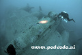
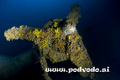
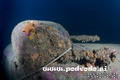
Nazwa dodatkowa Wrack, B-17 airplane wreck
Przeciętna głebokość 70 m / 229.7 ft
maksymalna głębokość 75 m / 246.1 ft
Prąd Powoli( < 1 knot)
Widoczność Dobry ( 10 - 30 m)
Jakość
Jakość miejsca nurkowania Dobry
Doświadczenie Kamikazes/Trimix
Interesujący biologicznie Słaby
Więcej informacji
Ilość nurków w tygodniu
Ilość nurków w week-end
Nurkowanie typu
- Wrak
- Głębokie
Aktywności w miejscu
- Fotografia
Niebezpieczeństwa
- Głebokość
Dodatkowe informacje
English (Przetłumacz ten tekst w Polski): A US Air Force B17G bomber that lies 72 metres under the surface, 100 metres off the southern shore of Vis. It fell from the sky in 1943, and the crew was rescued by local fishermen. Divers can see the guns, engines and all instrumentation clearly
English (Przetłumacz ten tekst w Polski): A US Air Force B17G bomber that lies 72 metres under the surface, 100 metres off the southern shore of Vis. It fell from the sky in 1943, and the crew was rescued by local fishermen. Divers can see the guns, engines and all instrumentation clearly
A US Air Force B17G bomber that lies 72 metres under the surface, 100 metres off the southern shore of Vis. It fell from the sky in 1943, and the crew was rescued by local fishermen. Divers can see the guns, engines and all instrumentation clearly
English (Przetłumacz ten tekst w Polski): A US Air Force B17G bomber that lies 72 metres under the surface, 100 metres off the southern shore of Vis. It fell from the sky in 1943, and the crew was rescued by local fishermen. Divers can see the guns, engines and all instrumentation clearly
English (Przetłumacz ten tekst w Polski): A US Air Force B17G bomber that lies 72 metres under the surface, 100 metres off the southern shore of Vis. It fell from the sky in 1943, and the crew was rescued by local fishermen. Divers can see the guns, engines and all instrumentation clearly
English (Przetłumacz ten tekst w Polski): A US Air Force B17G bomber that lies 72 metres under the surface, 100 metres off the southern shore of Vis. It fell from the sky in 1943, and the crew was rescued by local fishermen. Divers can see the guns, engines and all instrumentation clearly
English (Przetłumacz ten tekst w Polski): A US Air Force B17G bomber that lies 72 metres under the surface, 100 metres off the southern shore of Vis. It fell from the sky in 1943, and the crew was rescued by local fishermen. Divers can see the guns, engines and all instrumentation clearly
English (Przetłumacz ten tekst w Polski): A US Air Force B17G bomber that lies 72 metres under the surface, 100 metres off the southern shore of Vis. It fell from the sky in 1943, and the crew was rescued by local fishermen. Divers can see the guns, engines and all instrumentation clearly
English (Przetłumacz ten tekst w Polski): A US Air Force B17G bomber that lies 72 metres under the surface, 100 metres off the southern shore of Vis. It fell from the sky in 1943, and the crew was rescued by local fishermen. Divers can see the guns, engines and all instrumentation clearly
 Komentarze
Pokaż wszystko (0)...
To będzie pierwszy komentarz o tym kraju
Błąd, powiadom nas o błędzie
możesz skorygować te błędy lub dodać informacje. Jeśli masz problemy odwiedź ta stronę, Wyślij nam odpowiedź zwrotną.
Wannadive.net 24/24
Wannadive.net na Twoim urządzeniu mobilnym

Biuletyn Wiadomości na email
 B-17G
B-17G