Ta mapa jest interaktywna! Użyj kontrolek celem przybliżenia i oddalenia.
|
Data: WGS84 [ Pomocy ]
Dokładność: W przybliżeniu
Historia GPS (1)
|
Szerokość geograficzna: 19° 41.579' N
Długość geograficzna: 79° 52.991' W
|
Dostęp
|
English (Przetłumacz ten tekst w Polski): The MV Keith Tibbetts rests on the northern shores of Cayman Brac.
It is generally accessible only by boat, but can also be accessed (via a long swim) from the 'Bucaneer' shore access point: take a compass bearing off of one of the mooring balls and expect a moderate longitudinal current (typically east to west, which would be right-to-left on the swim out).
By boat, the site is moored (generally two moorings directly on the wreck, one forward and one to stern). The shore landmark to find the moorings is a cut in the ironshore located at the site of the old Bucaneer hotel property. This is easy to spot from a distance offshore because of a 25ft tall rockpile next to the cut. If the rockpile is ever removed, there's also two yellow marker signs that signify the border of the Marine Park located on the shore at the inlet.
If you miss the Bucaneer landmark, slightly further to the west is a rock jetty which is the Scott Development dock where they load gravel for export to Grand Cayman (and only occasionally killing the surrounding reef with accidental gravel spills). This jetty might be eventually made into a Cruise Ship dock for the Brac.
The MV Keith Tibbetts rests on the northern shores of Cayman Brac.
It is generally accessible only by boat, but can also be accessed (via a long swim) from the 'Bucaneer' shore access point: take a compass bearing off of one of the mooring balls and expect a moderate longitudinal current (typically east to west, which would be right-to-left on the swim out).
By boat, the site is moored (generally two moorings directly on the wreck, one forward and one to stern). The shore landmark to find the moorings is a cut in the ironshore located at the site of the old Bucaneer hotel property. This is easy to spot from a distance offshore because of a 25ft tall rockpile next to the cut. If the rockpile is ever removed, there's also two yellow marker signs that signify the border of the Marine Park located on the shore at the inlet.
If you miss the Bucaneer landmark, slightly further to the west is a rock jetty which is the Scott Development dock where they load gravel for export to Grand Cayman (and only occasionally killing the surrounding reef with accidental gravel spills). This jetty might be eventually made into a Cruise Ship dock for the Brac.
English (Przetłumacz ten tekst w Polski): The MV Keith Tibbetts rests on the northern shores of Cayman Brac.
It is generally accessible only by boat, but can also be accessed (via a long swim) from the 'Bucaneer' shore access point: take a compass bearing off of one of the mooring balls and expect a moderate longitudinal current (typically east to west, which would be right-to-left on the swim out).
By boat, the site is moored (generally two moorings directly on the wreck, one forward and one to stern). The shore landmark to find the moorings is a cut in the ironshore located at the site of the old Bucaneer hotel property. This is easy to spot from a distance offshore because of a 25ft tall rockpile next to the cut. If the rockpile is ever removed, there's also two yellow marker signs that signify the border of the Marine Park located on the shore at the inlet.
If you miss the Bucaneer landmark, slightly further to the west is a rock jetty which is the Scott Development dock where they load gravel for export to Grand Cayman (and only occasionally killing the surrounding reef with accidental gravel spills). This jetty might be eventually made into a Cruise Ship dock for the Brac.
Jak? Z łodzi i z brzegu
Odległość Dobry czas na łodzi (< 30min)
Łatwo znaleźć? Łatwe do znalezienia
|
|
Charakterystyka miejsca nurkowego
Nazwa dodatkowa 356 Russian Destroyer
Przeciętna głebokość 20 m / 65.6 ft
maksymalna głębokość 35 m / 114.8 ft
Prąd Powoli( < 1 knot)
Widoczność Wspaniały ( > 30 m)
Jakość
Jakość miejsca nurkowania Dobry
Doświadczenie Dla każdego nurka
Interesujący biologicznie Interesujący
Więcej informacji
Ilość nurków w tygodniu
Ilość nurków w week-end
Nurkowanie typu
- Wrak
- Ścianka
- Rafa
Aktywności w miejscu
- Biologia morska
- Trening nurkowy
- Orientacja
- Fotografia
Niebezpieczeństwa
- Podróż łodzią
Dodatkowe informacje
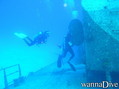
English (Przetłumacz ten tekst w Polski): The MV Captain Keith Tibbetts was sunk in 1996 as an artificial reef. Since then, coral has grown nicely on the wreck. The wreck has since had its back broken by a Winter Nor'Wester storm which has resulted in a nice debris field amidships. It remains an interesting wreck with plenty to see on the outside, plus there's a couple of well-known and reasonably safe penetration opportunities. Fish life is present and is typical for the region, with local DMs often aware of where a resident Scorpionfish or two are residing.
The area off the bow of the ship leads out into a deeper sandflat area, and then coral formations at the wall dropoff. This area is not frequented by most divers who come to this mooring, partly because it isn't the wreck proper, but also because the dropoff starts deep, in approximately 110fsw. As with any bluewater dropoff, pelagics can occasionally be spotted in this area.
The MV Captain Keith Tibbetts was sunk in 1996 as an artificial reef. Since then, coral has grown nicely on the wreck. The wreck has since had its back broken by a Winter Nor'Wester storm which has resulted in a nice debris field amidships. It remains an interesting wreck with plenty to see on the outside, plus there's a couple of well-known and reasonably safe penetration opportunities. Fish life is present and is typical for the region, with local DMs often aware of where a resident Scorpionfish or two are residing.
The area off the bow of the ship leads out into a deeper sandflat area, and then coral formations at the wall dropoff. This area is not frequented by most divers who come to this mooring, partly because it isn't the wreck proper, but also because the dropoff starts deep, in approximately 110fsw. As with any bluewater dropoff, pelagics can occasionally be spotted in this area.
English (Przetłumacz ten tekst w Polski): The MV Captain Keith Tibbetts was sunk in 1996 as an artificial reef. Since then, coral has grown nicely on the wreck. The wreck has since had its back broken by a Winter Nor'Wester storm which has resulted in a nice debris field amidships. It remains an interesting wreck with plenty to see on the outside, plus there's a couple of well-known and reasonably safe penetration opportunities. Fish life is present and is typical for the region, with local DMs often aware of where a resident Scorpionfish or two are residing.
The area off the bow of the ship leads out into a deeper sandflat area, and then coral formations at the wall dropoff. This area is not frequented by most divers who come to this mooring, partly because it isn't the wreck proper, but also because the dropoff starts deep, in approximately 110fsw. As with any bluewater dropoff, pelagics can occasionally be spotted in this area.
 Komentarze
Pokaż wszystko (0)...
To będzie pierwszy komentarz o tym kraju
Błąd, powiadom nas o błędzie
możesz skorygować te błędy lub dodać informacje. Jeśli masz problemy odwiedź ta stronę, Wyślij nam odpowiedź zwrotną.
 MV Captain Keith Tibbetts