Ta mapa jest interaktywna! Użyj kontrolek celem przybliżenia i oddalenia.
|
Data: WGS84 [ Pomocy ]
Dokładność: Dokładnie
Historia GPS (2)
|
Szerokość geograficzna: 7° 20.311' N
Długość geograficzna: 134° 26.024' E
|
Dostęp
|
English (Przetłumacz ten tekst w Polski): From the entrance to Malakal Harbor just around the North pincher a few yards. Often a mooring line on her
English (Przetłumacz ten tekst w Polski): From the entrance to Malakal Harbor just around the North pincher a few yards. Often a mooring line on her
From the entrance to Malakal Harbor just around the North pincher a few yards. Often a mooring line on her
English (Przetłumacz ten tekst w Polski): From the entrance to Malakal Harbor just around the North pincher a few yards. Often a mooring line on her
English (Przetłumacz ten tekst w Polski): From the entrance to Malakal Harbor just around the North pincher a few yards. Often a mooring line on her
English (Przetłumacz ten tekst w Polski): From the entrance to Malakal Harbor just around the North pincher a few yards. Often a mooring line on her
English (Przetłumacz ten tekst w Polski): From the entrance to Malakal Harbor just around the North pincher a few yards. Often a mooring line on her
English (Przetłumacz ten tekst w Polski): From the entrance to Malakal Harbor just around the North pincher a few yards. Often a mooring line on her
English (Przetłumacz ten tekst w Polski): From the entrance to Malakal Harbor just around the North pincher a few yards. Often a mooring line on her
Jak? Łodzią
Odległość Krótki czas na łodzi (< 10min)
Łatwo znaleźć? Łatwe do znalezienia
|
|
Charakterystyka miejsca nurkowego
Przeciętna głebokość 27 m / 88.6 ft
maksymalna głębokość 41 m / 134.5 ft
Prąd Powoli( < 1 knot)
Widoczność Średni( 5 - 10 m)
Jakość
Jakość miejsca nurkowania Świetny
Doświadczenie Dla każdego nurka
Interesujący biologicznie Interesujący
Więcej informacji
Ilość nurków w tygodniu
Ilość nurków w week-end
Nurkowanie typu
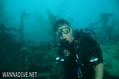
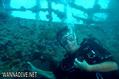
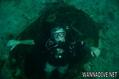
- Wrak
Aktywności w miejscu
- Biologia morska
- Nocne nurkowanie
- Trening nurkowy
- Fotografia
Niebezpieczeństwa
Dodatkowe informacje
English (Przetłumacz ten tekst w Polski): 502 Foot length, 66 Foot beam
10,000 Ton, Combined Fleet Tanker
Stinging Hydroids cover the marker buoy line to the ship.
She was attacked by aircraft from the Carrier Enterprise as part of Task Force 58, Operation Desecrate One, on March 30 and finished off the later that day by aircraft from the same Carrier .
502 Foot length, 66 Foot beam
10,000 Ton, Combined Fleet Tanker
Stinging Hydroids cover the marker buoy line to the ship.
She was attacked by aircraft from the Carrier Enterprise as part of Task Force 58, Operation Desecrate One, on March 30 and finished off the later that day by aircraft from the same Carrier .
English (Przetłumacz ten tekst w Polski): 502 Foot length, 66 Foot beam
10,000 Ton, Combined Fleet Tanker
Stinging Hydroids cover the marker buoy line to the ship.
She was attacked by aircraft from the Carrier Enterprise as part of Task Force 58, Operation Desecrate One, on March 30 and finished off the later that day by aircraft from the same Carrier .
 Komentarze
Pokaż wszystko (0)...
To będzie pierwszy komentarz o tym kraju
Błąd, powiadom nas o błędzie
możesz skorygować te błędy lub dodać informacje. Jeśli masz problemy odwiedź ta stronę, Wyślij nam odpowiedź zwrotną.
Wannadive.net 24/24
Wannadive.net na Twoim urządzeniu mobilnym

Biuletyn Wiadomości na email
 Amatsu Maru