Utracono hasło? Nowy użytkownik? Zarejestruj się
Clownfish, Philippines. Photo by Stephane Rochon.
Baw się i pomagaj!
| Znajdź najlepsze miejsce nurkowe |
|
|
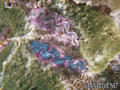
 Batu Nisan
Malaysia, Peninsular Malaysia, Perhentian Islands
Ta mapa jest interaktywna! Użyj kontrolek celem przybliżenia i oddalenia.
|
Data: WGS84 [ Pomocy ] |
Szerokość geograficzna: 5° 55.225' N |
Ocena użytkownika (0)
- Ulubione
-
Twoje ulubione i przyszłe miejsca nurkowe
Dostęp
|
English (Przetłumacz ten tekst w Polski): Eastern side of Palau Prehentian Kecil island Jak? Łodzią Odległość Krótki czas na łodzi (< 10min) Łatwo znaleźć? Nie wiem |
Charakterystyka miejsca nurkowego
Nazwa dodatkowa Tombstone
Przeciętna głebokość 10 m / 32.8 ft
maksymalna głębokość 12 m / 39.4 ft
Prąd Nie wiem
Widoczność Dobry ( 10 - 30 m)
Jakość
Jakość miejsca nurkowania Dobry
Doświadczenie CMAS * / OW
Interesujący biologicznie Interesujący
Więcej informacji
Ilość nurków w tygodniu
Ilość nurków w week-end
Nurkowanie typu
- Rafa
Aktywności w miejscu
- Pierwsze nurkowanie
Niebezpieczeństwa
- Niebezpieczne zwierzęta
Dodatkowe informacje
Autor: Anonimowy Współpracownicy (1) Oni nurkowali w tym miejscu! (19)
 Zdjecia

Batu Nisan |
Batu Nisan |
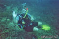
Batu Nisan |
Dive logs
|
Komentarze
To będzie pierwszy komentarz o tym kraju
Błąd, powiadom nas o błędzie
możesz skorygować te błędy lub dodać informacje. Jeśli masz problemy odwiedź ta stronę, Wyślij nam odpowiedź zwrotną.