Utracono hasło? Nowy użytkownik? Zarejestruj się
Clownfish, Philippines. Photo by Stephane Rochon.
Baw się i pomagaj!
| Znajdź najlepsze miejsce nurkowe |
|
|
 Million Hope Wreck
Egypt, Strait of Tiran
Ta mapa jest interaktywna! Użyj kontrolek celem przybliżenia i oddalenia.
|
Data: WGS84 [ Pomocy ] |
Szerokość geograficzna: 28° 3.399' N |
Ocena użytkownika (0)
- Ulubione
-
Twoje ulubione i przyszłe miejsca nurkowe
Dostęp
|
English (Przetłumacz ten tekst w Polski): Located 3 miles N of Sharm El Sheikh, on the E coast of Sinai peninsula. Much of its superstructure is still out of the water, so it's easy to find it! Jak? Łodzią Odległość Długi czas na łodzi Łatwo znaleźć? Łatwe do znalezienia |
Charakterystyka miejsca nurkowego
Nazwa dodatkowa Millon Hope, Ryusei Maru
Przeciętna głebokość 10.0 m / 32.8 ft
maksymalna głębokość 22.0 m / 72.2 ft
Prąd Powoli( < 1 knot)
Widoczność Dobry ( 10 - 30 m)
Jakość
Jakość miejsca nurkowania Dobry
Doświadczenie Dla każdego nurka
Interesujący biologicznie Słaby
Więcej informacji
Ilość nurków w tygodniu
Ilość nurków w week-end
Nurkowanie typu
- Wrak
- Rafa
Aktywności w miejscu
- Fotografia
Niebezpieczeństwa
Dodatkowe informacje
English (Przetłumacz ten tekst w Polski): Type: Cargo
Vessel size: 174.6m x 24.8m
Autor: Anonimowy Współpracownicy (1) Oni nurkowali w tym miejscu! (8)
 Zdjecia
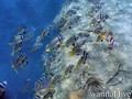
Million Hope Wreck |
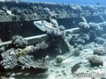
Million Hope Wreck |
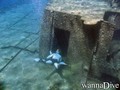
Million Hope Wreck |
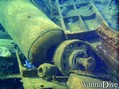
Million Hope Wreck |
Wycieczki nurkowe
|
Komentarze
To będzie pierwszy komentarz o tym kraju
Błąd, powiadom nas o błędzie
możesz skorygować te błędy lub dodać informacje. Jeśli masz problemy odwiedź ta stronę, Wyślij nam odpowiedź zwrotną.