Utracono hasło? Nowy użytkownik? Zarejestruj się
Whale Shark, Philippines. Photo by Stephane Rochon.
Baw się i pomagaj!
| Znajdź najlepsze miejsce nurkowe |
|
|
 Portugal
Europa
Dive portugal and it's famous and old wrecks !
Lokalizacja: Southwestern Europe, bordering the North Atlantic Ocean, west of Spain
Koordynaty geograficzne: 39° 18' N, 8° 0' W
Linia brzegowa: 1,793 km km
Klimat: maritime temperate; cool and rainy in north, warmer and drier in south
Teren: mountainous north of the Tagus River, rolling plains in south
Najwyższy punkt: highest point: Ponta do Pico (Pico or Pico Alto) on Ilha do Pico in the Azores 2,351 m
Naturalne zagrożenia: Azores subject to severe earthquakes
Waluta: euro (EUR)
Populacja: 10,566,212 (July 2005 est.)
Języki: Portuguese (official), Mirandese (official - but locally used)
Stolica: Lisbon
Podział: 18 districts (distritos, singular - distrito) and 2 autonomous regions* (regioes autonomas, singular - regiao autonoma); Aveiro, Acores (Azores)*, Beja, Braga, Braganca, Castelo Branco, Coimbra, Evora, Faro, Guarda, Leiria, Lisboa, Madeira*, Portalegre, Porto, Santarem, Setubal, Viana do Castelo, Vila Real, Viseu
Więcej szczegółów
| Jan | Feb | Mar | Apr | May | Jun | Jul | Aug | Sep | Oct | Nov | Dec | |
|---|---|---|---|---|---|---|---|---|---|---|---|---|
| Climate | ||||||||||||
| Air temp. | ||||||||||||
| Water temp. | ||||||||||||
| Equipment | ||||||||||||
| Best season | ||||||||||||
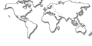
Dodatkowa mapa
Chcesz dodać jakąś informację o Portugal? Znamy....
Ta mapa jest interaktywna! Użyj kontrolek celem przybliżenia i oddalenia.
- dive logs (39)
- podróże (1)
- Zdjecia (160)
- Filmy (1)
- Podziel się
- Ulubione
-
Twoje ulubione i przyszłe miejsca nurkowe
Twój ulubiony obszar nie jest wyswietlany? Dodaj obszar
Miejsca
| Miejsca (4) | Miejsca nurkowania | Pod-obszary |
|---|---|---|
| Alentejo | 1 | 0 |
| Algarve | 46 | 4 |
| Lisboa | 25 | 2 |
| Norte | 23 | 2 |
 Zdjecia

Armacao de Pera |
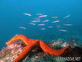
Armacao de Pera |
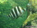
Armacao de Pera |
Armacao de Pera |
Dive logs
|
Komentarze
To będzie pierwszy komentarz o tym kraju
Błąd, powiadom nas o błędzie
Jeśli chcesz dodać nowe informacje lub znalazłeś błędy w opisie tego kraju, Wyślij nam odpowiedź zwrotną.