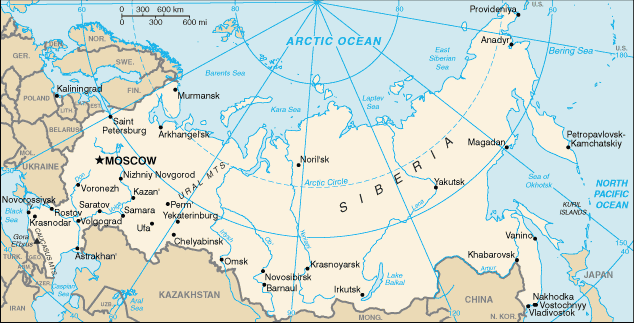
Lokalizacja: Northern Asia (the area west of the Urals is considered part of Europe), bordering the Arctic Ocean, between Europe and the North Pacific Ocean
Koordynaty geograficzne: 60° 0' N, 100° 0' E
Linia brzegowa: 37,653 km km
Klimat: ranges from steppes in the south through humid continental in much of European Russia; subarctic in Siberia to tundra climate in the polar north; winters vary from cool along Black Sea coast to frigid in Siberia; summers vary from warm in the steppes to cool along Arctic coast
Teren: broad plain with low hills west of Urals; vast coniferous forest and tundra in Siberia; uplands and mountains along southern border regions
Najwyższy punkt: lowest point: Caspian Sea -28 m
highest point: Gora El'brus 5,633 m
Naturalne zagrożenia: permafrost over much of Siberia is a major impediment to development; volcanic activity in the Kuril Islands; volcanoes and earthquakes on the Kamchatka Peninsula; spring floods and summer/autumn forest fires throughout Siberia and parts of European Russia.
Waluta: Russian ruble (RUR)
Populacja: 141,377,752 (July 2007 est.)
Języki: Russian, many minority languages
Stolica: Moscow
Podział: 12 regions: Central, Central Black Earth, East Siberian, Far Eastern, Northern, North Caucasus, Northwestern, Volga, Urals, Volga-Vyatka, West Siberian, Kaliningrad
Dodatkowa mapa

Chcesz dodać jakąś informację o Russia? Znamy....
Ta mapa jest interaktywna! Użyj kontrolek celem przybliżenia i oddalenia.
Twój ulubiony obszar nie jest wyswietlany? Dodaj obszar
Miejsca
Twoje ulubione nurkowania nie wyświetlają się? Dodaj miejsce
Miejsca nurkowania
| Miejsca nurkowania (8) |
|
 |
Jakość |
Średnia głębokość |
Maksymalna głębokość |
Doświadczenie |
Typ nurkowania |
| Bungur Black island |
- / - |

|
|
49.2 ft |
131.2 ft |
Dla każdego nurka |

|
| Ingol' Lake |
2 / - |

|
|
65.6 ft |
308.4 ft |
Dla każdego nurka |


|
| Konopelka |
2 / - |

|
|
29.5 ft |
49.2 ft |
Dla każdego nurka |


|
| Lake Teletskoye |
- / - |

|
|
23 ft |
1066.3 ft |
Dla każdego nurka |


|
| Lake Vad |
5 / - |

|
|
ft |
ft |
Dla każdego nurka |


|
| Oazis |
3 / - |

|
|
29.5 ft |
42.7 ft |
CMAS * / OW |


|
| Temir |
3 / - |

|
|
131.2 ft |
328.1 ft |
Dla każdego nurka |


|
| Zaboy |
3 / - |

|
|
16.4 ft |
26.2 ft |
CMAS * / OW |


|
 Komentarze
Pokaż wszystko (0)...
To będzie pierwszy komentarz o tym kraju
Błąd, powiadom nas o błędzie
Jeśli chcesz dodać nowe informacje lub znalazłeś błędy w opisie tego kraju, Wyślij nam odpowiedź zwrotną.
Wannadive.net 24/24
Wannadive.net na Twoim urządzeniu mobilnym

Biuletyn Wiadomości na email
 Russia


 Dive logs
 Komentarze


