Utracono hasło? Nowy użytkownik? Zarejestruj się
Lizard fish, Philippines. Photo by Stephane Rochon.
Baw się i pomagaj!
| Znajdź najlepsze miejsce nurkowe |
|
|
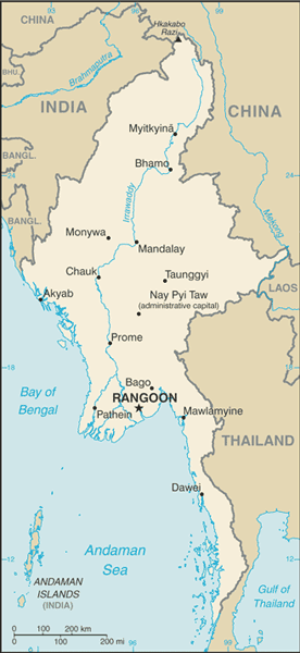
 Burma
Burma
Azja
Burma, officially the Union of Myanmar, is the largest country by geographical area in mainland Southeast Asia or Indochina. The country is bordered by China on the northeast, Laos on the east, Thailand on the southeast, Bangladesh on the west, India on the northwest and the Bay of Bengal to the southwest with the Andaman Sea defining its southern periphery. One-third of Burma's total perimeter, 1,930 kilometres (1,199 mi), forms an uninterrupted coastline.
Lokalizacja: Southeastern Asia, bordering the Andaman Sea and the Bay of Bengal, between Bangladesh and Thailand
Koordynaty geograficzne: 22° 0' N, 98° 0' E
Linia brzegowa: 1,930 km km
Klimat: tropical monsoon; cloudy, rainy, hot, humid summers (southwest monsoon, June to September); less cloudy, scant rainfall, mild temperatures, lower humidity during winter (northeast monsoon, December to April)
Teren: central lowlands ringed by steep, rugged highlands
Najwyższy punkt: lowest point: Andaman Sea 0 m
highest point: Hkakabo Razi 5,881 m
Naturalne zagrożenia: petroleum, timber, tin, antimony, zinc, copper, tungsten, lead, coal, marble, limestone, precious stones, natural gas, hydropower
Waluta: kyats (MMK)
Populacja: 48,137,741 (July 2009 est.)
Języki: Burmese, minority ethnic groups have their own languages
Stolica: Rangoon (Yangon)
Podział: 7 divisions and 7 states:
- divisions: Ayeyarwady, Bago, Magway, Mandalay, Sagaing, Tanintharyi, Yangon
- states: Chin, Kachin, Kayah, Kayin, Mon, Rakhine, Shan
Więcej szczegółów
| Jan | Feb | Mar | Apr | May | Jun | Jul | Aug | Sep | Oct | Nov | Dec | |
|---|---|---|---|---|---|---|---|---|---|---|---|---|
| Climate | ||||||||||||
| Air temp. | ||||||||||||
| Water temp. | ||||||||||||
| Equipment | No ho sé | No ho sé | No ho sé | No ho sé | No ho sé | No ho sé | No ho sé | No ho sé | No ho sé | No ho sé | No ho sé | No ho sé |
| Best season | ||||||||||||
Dodatkowa mapa
Chcesz dodać jakąś informację o Burma? Znamy....
Ta mapa jest interaktywna! Użyj kontrolek celem przybliżenia i oddalenia.
- dive logs (0)
- podróże (0)
- Zdjecia (7)
- Filmy (4)
- Podziel się
- Ulubione
-
Twoje ulubione i przyszłe miejsca nurkowe
Twój ulubiony obszar nie jest wyswietlany? Dodaj obszar
Miejsca
| Miejsca (1) | Miejsca nurkowania | Pod-obszary |
|---|---|---|
| Mergui Archipelago | 6 | 0 |
Miejsca nurkowania
| Miejsca nurkowania (1) | Jakość | Średnia głębokość | Maksymalna głębokość | Doświadczenie | Typ nurkowania | ||
|---|---|---|---|---|---|---|---|
| Silvertip Bank | - / - | 59.1 ft | 98.4 ft | CMAS * / OW | 
|

 Filmy
Filmy
 04:54
04:54
|
 04:00
04:00
|
 04:13
04:13
|
 03:32
03:32
|
Komentarze
Błąd, powiadom nas o błędzie
Jeśli chcesz dodać nowe informacje lub znalazłeś błędy w opisie tego kraju, Wyślij nam odpowiedź zwrotną.