Utracono hasło? Nowy użytkownik? Zarejestruj się
Lizard fish, Philippines. Photo by Stephane Rochon.
Baw się i pomagaj!
| Znajdź najlepsze miejsce nurkowe |
|
|
 Seychelles
Afryka
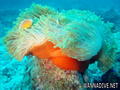
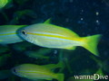
The marine life around the islands, especially the more remote coral islands, can be spectacular. More than 1000 species of fish have been recorded. Since the use of spearguns and dynamite for fishing was banned through efforts of local conservationists in the 1960s, the wildlife is unafraid of snorkelers and divers. Coral bleaching in 1998 has unfortunately damaged most reefs. The reefs comprise of a vast selection of soft corals and hard corals alike. There is great diving and snorkeling opportunity. The taking of marine turtles was completely stopped in 1994, turtle populations are now recovering on several islands, most notably Cousin Island, Silhouette Island and Aldabra. The use of gill nets for shark fishing as well as the practice of shark finning are now banned.
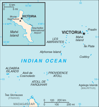
Lokalizacja: Archipelago in the Indian Ocean, northeast of Madagascar
Koordynaty geograficzne: 4° 35' S, 55° 40' E
Linia brzegowa: 491 km km
Klimat: tropical marine; humid; cooler season during southeast monsoon (late May to September); warmer season during northwest monsoon (March to May)
Teren: Mahe Group is granitic, narrow coastal strip, rocky, hilly; others are coral, flat, elevated reefs
Najwyższy punkt: lowest point: Indian Ocean 0 m
highest point: Morne Seychellois 905 m
Naturalne zagrożenia: lies outside the cyclone belt, so severe storms are rare; short droughts possible
Waluta: Seychelles rupee (SCR)
Populacja: 81,895 (July 2007 est.)
Języki: Creole 91.8%, English 4.9% (official), other 3.1%, unspecified 0.2% (2002 census)
Stolica: Victoria
Podział: 23 administrative districts; Anse aux Pins, Anse Boileau, Anse Etoile, Anse Louis, Anse Royale, Baie Lazare, Baie Sainte Anne, Beau Vallon, Bel Air, Bel Ombre, Cascade, Glacis, Grand' Anse (on Mahe), Grand' Anse (on Praslin), La Digue, La Riviere Anglaise, Mont Buxton, Mont Fleuri, Plaisance, Pointe La Rue, Port Glaud, Saint Louis, Takamaka
Więcej szczegółów
| Jan | Feb | Mar | Apr | May | Jun | Jul | Aug | Sep | Oct | Nov | Dec | |
|---|---|---|---|---|---|---|---|---|---|---|---|---|
| Climate | ||||||||||||
| Air temp. | ||||||||||||
| Water temp. | ||||||||||||
| Equipment | Não sei | Não sei | Não sei | Não sei | Não sei | Não sei | Não sei | Não sei | Não sei | Não sei | Não sei | Não sei |
| Best season | ||||||||||||
Dodatkowa mapa
Chcesz dodać jakąś informację o Seychelles? Znamy....
Ta mapa jest interaktywna! Użyj kontrolek celem przybliżenia i oddalenia.
- dive logs (3)
- podróże (0)
- Zdjecia (38)
- Filmy (2)
- Podziel się
- Ulubione
-
Twoje ulubione i przyszłe miejsca nurkowe
Twój ulubiony obszar nie jest wyswietlany? Dodaj obszar
Miejsca
| Miejsca (2) | Miejsca nurkowania | Pod-obszary |
|---|---|---|
| Inner Islands | 31 | 5 |
| Outer Islands | 6 | 0 |
 Zdjecia
Bay Ternay Marine Park |

Bay Ternay Marine Park |
Beau Vallon Reef |
Beau Vallon Reef |
Dive logs
|
Komentarze
Obok peru , 03-09-2017
REMIRE island - E' l'isola riservata del Presidente delle Seychelles. Ci sono stato nel 1998 con la mia imbarcazione, ancorandomi a nord (200 mt dall'isola dove ci sono banchi di sabbia a - 5/6 mt.) Ho fatto belle immersioni sull'im-menso reef a nor/est. Rifornito la cambusa (aragoste, trovate nel reef a ovest (-2/3 mt, a 100 mt dall'isola)
Błąd, powiadom nas o błędzie
Jeśli chcesz dodać nowe informacje lub znalazłeś błędy w opisie tego kraju, Wyślij nam odpowiedź zwrotną.